Background
Tropical cyclones typically occur in the northern part of Australia between the start of November until the end of April (cyclone season). These significant weather events pose a serious risk to maritime safety, particularly in the event of an engineering failure at sea in the vicinity of a cyclone.
AMSA has recently observed instances where piloted vessels have navigated close to a tropical cyclone, where the effects of the cyclone on the prevailing wind, waves and sea conditions have made safe navigation difficult.
In one instance an engineering breakdown occurred in close proximity to the cyclone, necessitating the vessel to depart the Inner Route pilotage area and exit the reef. This was particularly challenging given the vessel’s reduced power and sea-keeping ability amidst the prevailing conditions.
AMSA considers these situations to be unnecessary and in the majority of instances, avoidable through appropriate passage planning and risk assessment.
Requirement
If a voyage is intended when a tropical cyclone is known to exist in, or nearby, a coastal pilotage area, AMSA-licensed coastal pilots are required to plan (and/or delay) the conduct of the voyage, so as to avoid interaction with the cyclone to the extent required to ensure maritime safety prevails at all times.
It is acknowledged that the path of a cyclone can be erratic, and its track may change while a voyage is underway. In any case, coastal pilots are required to monitor the forecast track of the cyclone and adjust the passage plan, in order to avoid interaction with the cyclone and maintain a safe distance as required.
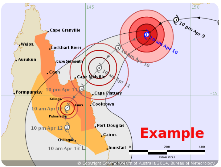
As a minimum, coastal piloted vessels should not proceed within the area depicted by the coloured circles (or the corresponding forecast circles) on a tropical cyclone forecast track map, such as shown in the example below. These areas represent the cyclone’s destructive core and winds which are to be avoided.
Licence Condition
Schedule 3 of Marine Order 54 (Coastal pilotage) indicates if a pilot holds a restricted or unrestricted pilot licence, that the pilot must “give information and advice to the master of the vessel to assist the master and the vessel’s navigating officers to make safe passage through the pilotage area”.
A coastal pilot that deliberately takes a vessel into the path of, or in close proximity to, a tropical cyclone, where it could have otherwise been avoided through appropriate planning and risk assessment, may be found to have breached this particular licence condition.
In such circumstances, AMSA may pursue regulatory action against a pilot accordingly.
Warning Signs
Tropical cyclones typically form between 5º and 15º south in the southern hemisphere. The following warning signs may be relevant for an approaching or developing tropical cyclone:
- Very low surface pressure, or a 24-hour change of 4 hPa or more.
- An unusual wind direction. Consideration should be given to land/sea breezes or other topographical effects.
- Wind speeds 25% or more above the mean which is around 7-10 knots across northern Australia during the cyclone season, particularly if the flow curves cyclonically.
- Long period swell, especially from an unusual direction. Normal swell in the Coral Sea is southeast. Any departure from this should be viewed with suspicion.
- A solid overcast of cirrostratus cloud thickening and lowering, particularly at several adjacent reporting stations,
- The ceasing of the diurnal fluctuation in barometric air pressure.
Cyclone Avoidance
If a coastal piloted vessel finds itself within close proximity to a tropical cyclone due to a significant change in the cyclone’s forecast track, the following information may be useful.
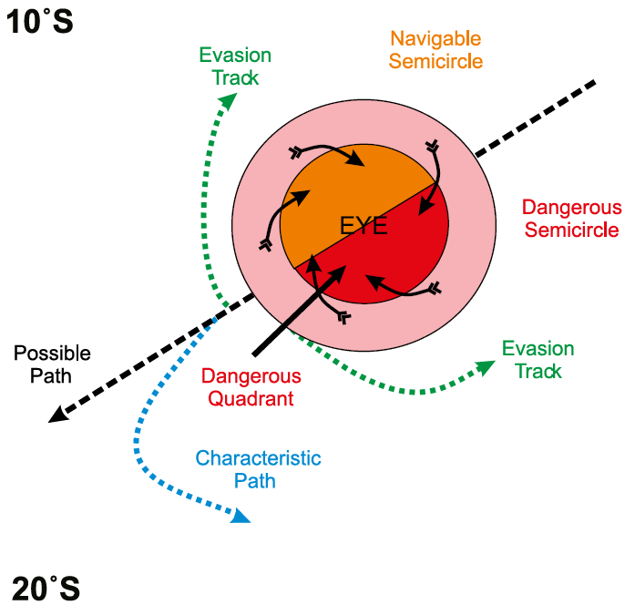
Whilst the movement of a tropical cyclone can be unpredictable and the associated winds irregular, it is possible to identify two key areas of a cyclone, namely the ‘dangerous’ and ‘navigable’ semi-circles. The action required to evade the cyclone is dependent on which semi-circle the vessel is located within.
The dangerous semi-circle has the strongest winds and is the direction in which the tropical cyclone is expected to move. The strongest winds occur because the direction of movement of the system is roughly the same as the direction of the winds.
The safety and avoidance rules described below are for cyclones in the southern hemisphere:
- Ensure the vessel has plenty of sea room to avoid being blown aground. This will require early decision-making, particularly if no natural havens are located throughout the intended passage.
- If possible, manoeuvre the ship to the navigable semi-circle to avoid danger from the possible re-curvature of the system to the south.
- If caught in the dangerous semi-circle, place the wind on the port bow and make best speed, keeping the wind in this position. This will result in the ship manoeuvring out of the storm by the most direct route.
- If caught in the navigable semi-circle, place and maintain the wind on the port quarter. This will also result in the ship manoeuvring out of the storm by the most direct route.
BoM Tropical Cyclone Outlook
As part of the expected risk assessment process, coastal pilots are required to obtain and monitor information about the likely development, or the existence of, a tropical cyclone which may impact on navigation relevant to a planned voyage in a coastal pilotage area.
Information regarding the possible interaction with a tropical cyclone should be taken into account and the vessel’s passage planned accordingly, to avoid the cyclone and the associated sea conditions to the maximum extent reasonably practicable.
In Australia, detailed information regarding the presence (or likely formation) of a tropical cyclone is available from the BoM website. After the formation of a tropical cyclone, BoM also provide regular updates regarding the cyclone’s forecast track, wind strengths and areas to avoid.
BoM issues a daily ‘Tropical Cyclone Outlook’ during the tropical cyclone season for the Coral Sea (available here: http://www.bom.gov.au/qld/forecasts/cyclone.shtml).
The Outlook contains either a statement that no cyclones are expected to develop in the next three days, or a brief explanation of the weather situation and the probability of tropical cyclone development on each of the following three days.
The Tropical Cyclone Outlook may also contain statements about the probability of a tropical cyclone forming within the next week (over the next seven days, rather than just the next three days) when there are clear signs of an increase in risk over that period.
The Tropical Cyclone Outlook may be updated if there is a significant change in the forecast.
Coastal pilots should monitor the available information closely and plan accordingly.
Additional Information
The following BoM web pages also provide relevant reference information about tropical cyclones:
- http://www.bom.gov.au/cyclone/
- http://www.bom.gov.au/cyclone/tropical-cyclone-knowledge-centre/
- http://www.bom.gov.au/cyclone/tropical-cyclone-knowledge-centre/warnings/
Additional general information about tropical cyclones in Australian waters is also available in these reference books:
- Mariner’s Handbook for Australian Waters (AHP20)
- Admiralty Sailing Directions. Australia Pilot Vol III (NP15)
Please forward any queries about this PAN to coastal.pilotage@amsa.gov.au