Information can be shared between ships, search and rescue aircraft, shore stations and aids to navigation (AtoN).
AIS stations are identified by a unique, nine-digit, maritime mobile service identity (MMSI), which is transmitted over the VHF radio spectrum. Two frequencies are specifically allocated for sharing AIS data (AIS 1 - 161.975 MHz and AIS 2 - 162.025 MHz). Each MMSI is transmitted using appropriate AIS messages. For an AIS AtoN, this is known as ‘Message 21’ and includes information such as name, position and operational status of the AtoN.
AIS AtoN messages can be broadcast from an AIS station located physically at an AtoN (termed ‘physical AIS AtoN’), or from a remote location (such as an AIS base station). An AIS AtoN message transmitted from a remote location for an AtoN that does not physically exist is called a ‘virtual AIS AtoN’.
AIS AtoN can enhance the safety of navigation via one or more of the following means*:
- Providing a positive, all-weather means of identification of an AtoN
- Complementing existing AtoN (e.g. lights, RACONs, etc.)
- Transmitting accurate positions of floating AtoN
- Indicating if a floating AtoN is off-position
- Enabling rapid marking of new hazards using Virtual AIS AtoN
- Enabling the establishment of AtoN in remote locations
- Gathering real-time information on the ‘state of health’ of an AtoN.
*The list above is not exhaustive.
IMO guidance
In 2014, the International Maritime Organization (IMO) issued MSC.1/Circ.1473 ‘Policy on use of AIS Aids to Navigation’. This document included information on definitions, performance standards, operational matters and other related topics.
IALA guidance
The International Organization for Marine Aids to Navigation (IALA) provides a range of guidance on the technical and operational aspects of AIS and its use as an AtoN on its website.
ITU guidance
The International Telecommunication Union (ITU) mandates MMSI requirements in Recommendation ITU-R M.585 (incorporated by reference in the Radio Regulations). The ITU also provides the technical standard for AIS in Recommendation ITU-R M.1371 (as in force from time to time).
MMSI
MMSIs are comprised of a series of nine digits which are transmitted over the radio path in order to uniquely identify ship stations, ship earth stations, coast stations, coast earth stations, and other non-shipborne stations operating in the maritime mobile service, or the maritime mobile-satellite service, and group calls.
MMSI for AIS AtoN
In accordance with Recommendation ITU-R M.585, all AIS AtoN should be assigned a unique MMSI number by AMSA in the following format:
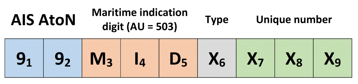
- M3 I4 D5 is the maritime identification digit (MID) and denotes the administration having jurisdiction over the AIS station so identified. The Australian MID is 503.
- X6 X7 X8 X9 may be any digit from 0 to 9
- X6 may be used by the administration to differentiate between certain specific uses:
- X6 = 1 for a physical AIS AtoN
- X6 = 6 for a virtual AIS AtoN
- X7 X8 X9 is a unique number (between 000 and 999) assigned to the AIS station
Errors and actions
If, in a coastal pilot’s opinion, incorrect AIS AtoN information is being displayed on the ship’s onboard ECDIS / navigational display(s) or the pilot’s Portable Pilot Unit (PPU), this should be reported to AMSA using the Report a Marine Safety Concern form.
Presentation of navigation-related symbols, terms and abbreviations
In 2019, the IMO issued SN.1/Circ.243/Rev.2 ‘Guidelines for the presentation of navigation-related symbols, terms and abbreviations’, with a view to harmonising the requirements for the presentation of navigation-related information on the bridge. These guidelines sought to ensure that all navigational displays adopt a consistent human-machine interface philosophy and implementation. These requirements come into effect from 2024/25. Until then, SN.1/Circ.243/Rev.1 Guidelines for the presentation of navigation-related symbols, terms and abbreviations, issues in 2014, should be used as the prevailing reference.
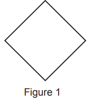
Physical AIS AtoN
Physical AIS AtoN shall be presented as an ‘open diamond’. The diamond shall be drawn using a thin solid line style (see Figure 1 below).
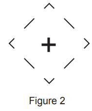
Virtual AIS AtoN
Virtual AIS AtoN shall be presented as an ‘open diamond with crosshair centred at reported position’. The diamond shall be drawn using a thin dashed line style (see Figure 2 below).
Further information about AIS AtoN symbology can be found in IMO SN.1/Circ.243/Rev.1 and 2: ‘Guidelines for the Presentation of Navigational-Related Symbols, Terms and Abbreviations’ (available via the IMO website).