Background
In response to historical concerns by the local community on Poruma Island, AMSA commissioned the Queensland Government Hydraulics Laboratory (QGHL) to study the potential impact of wake waves emanating from vessels transiting the GNEC pilotage area.
The QGHL study included a focus on community safety on Poruma Island (among other things).
As part of the study, QGHL gathered months of ‘round-the-clock’ wave and tidal data, including field measurements from wave monitoring buoys deployed to the north, south, east and west of Poruma Island, including on the inner edges of both eastern and western shipping channels.
Study results
QGHL’s data analysis showed that while vessel wake waves do not significantly contribute to erosion (and are unlikely to damage jetty infrastructure and moorings), the safety of the Poruma Island community remains a concern.
This is primarily due to the generation of larger wake waves (up to 1.15 metres in height) recorded on calm sea days1.
The study showed that these waves can be generated by vessels a significant distance (many nautical miles) from the island and can arrive at the island without warning, including when a ship is not in sight.
Such wake waves may potentially rock, swamp or capsize smaller vessels, which can cause serious injury to passengers and crew, as a result of being thrown off balance or overboard.
While it is acknowledged that the size and severity of vessel wake is linked to several factors, including vessel draught and hull design, the study found that slower vessel speeds would reduce the wake wave size and therefore reduce the associated safety risks to the Poruma Island community.
Requirement
If safe and practicable do so, coastal pilots and masters onboard vessels travelling both southbound and northbound (in both the eastern and western sections of the Two-Way Route (TWR) either side of Poruma Island), are requested to reduce speed to minimise vessel wake.
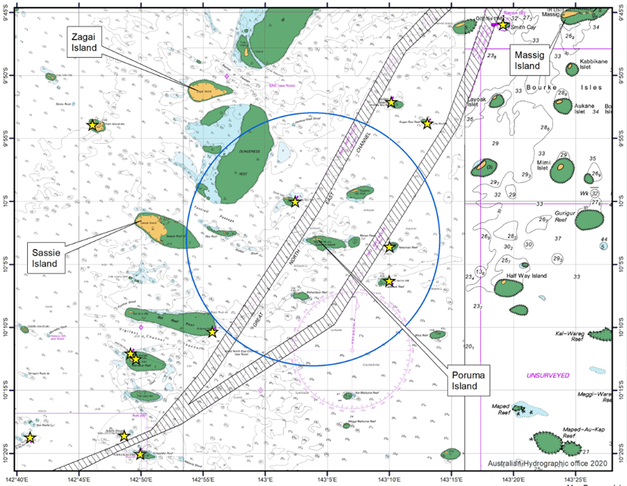
Specifically, vessels are requested to not exceed 15 knots when transiting within a distance of 10 nautical miles measured from the western side of Poruma Island, on a ‘calm sea day’.
Figure 1. below provides an indication of the approximate area in which vessel speed reductions are sought in this location.
Additionally, when transiting in the TWR west of Poruma Island, vessels are requested to navigate as far to the west of the island as possible (whilst remaining within the TWR), if safe and practicable to do so.
A chart note reflecting the information contained herein will be placed on the respective AUS navigational paper chart and electronic navigational chart (ENC), in due course.
Please forward any queries to coastal.pilotage@amsa.gov.au.
Footnotes
1 A ‘calm sea day’ is a day when the maximum wave height is less than 0.8m