S-100 is a new standard that will deliver navigation information in real time, beyond what is currently available directly to the Electronic Chart Display and Information System (ECDIS), removing the need for human intervention, that is, manually plotting information and enabling information that is traditionally external to the ECDIS to be in a one stop shop.
While the framework for how the data gets to and from the ships is still being developed it is expected that it will be IP-based, meaning ships will just require an internet connection from any source. Existing communication systems don't support the S-100 file types and size.
Benefits of S-100
S-100 services are expected to deliver:
- Streamlined access to information - seafarers will no longer need to consult multiple
sources of information. Instead, their navigation systems will seamlessly consolidate,
verify, and present all relevant inputs in real time - delivering a unified, accurate, and
timely picture that enhances decision making and safety at sea. - Improved safety and efficiency - near real-time updates mean that vessels will be aware
of what is happening in their surroundings as soon as data is made available by the data
producer, allowing for faster and more accurate decision-making, which helps reduce
risks and delays. - Route planning - a recent study looking at the economic and environment performance
improvements based on S-100 hydrographic information found that it is likely ships can
see a 14.6% fuel reduction.
Ship equipment requirements
To enjoy the benefits of S-100 products, ships will need an S-100 compatible ECDIS or compatible Electronic Navigation Chart (ENC) display device such as a Portable Pilot Unit (PPU) (used by marine pilots).
All new build SOLAS ships are required to have an S-100 ECDIS from 1 Jan 2029 and all existing SOLAS ships are required to replace their ECDIS when end of life is reached with an S-100 ECDIS from 1 Jan 2029.
While it is mandated for SOLAS ships anyone can use an S100 ECDIS and enjoy the benefits of the new services.
S-100 framework
For S-100 services to be delivered a new framework needs to be developed. As mentioned before this is under development at the International Maritime Organisation but is being designed around IP connectivity (internet) for how the data moves from ship to shore and ship to ship.
To ensure the IP network is secure and the data knows where to go, a Maritime Connectivity Platform (MCP) is being developed. This essentially sits between the sender and recipient of the data and will authenticate each end and provides a directory for the products. A ship can be anywhere in the world and will know what products are available to it in any location.
More detailed explanations of the MCP and S-100 framework can be found at:
- Maritime Connectivity Platform
- S-100 Universal Hydrographic Data Model at the International Hydrographic Organization
- MCP test instance at the International Organisation for Marine Aids to Navigation.
S-100 standard
As S-100 services are envisioned to be produced world-wide there needs to be a guarantee that the ship will receive the same standard of information no matter where they access the information. To ensure this happens the S-100 products have been designed around the IHO Universal Hydrographic Data Model S-100 which is an ISO 19100-based geospatial standard. It supports various types of data sources.
S-100 products
S-100 will deliver the below products. Some will be in real time, and others will be downloaded prior to departure as they currently are such as charts (S101).
This image depicts information about maritime navigation and data standards. It is divided into several sections, each illustrating different aspects of marine navigation and safety. It displays a range of S-100 based data products designated for specific maritime information
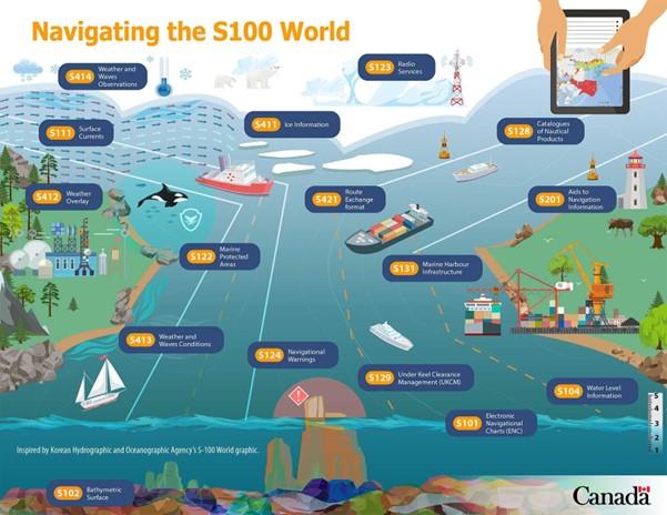
Image courtesy Fisheries and Oceans Canada (DFO)
This image depicts information about maritime navigation and data standards. It is divided into several sections, each illustrating different aspects of marine navigation and safety. It displays a range of S-100 based data models designated for specific maritime information. The different data models are:
S101 - Electronic Navigational Charts (ENC)
S102 - Bathymetric Surface
S104 - Water Level Information
S111 - Surface Currents
S122 - Marine Protected Areas
S123 - Radio Services
S124* - Navigational Warnings
S125* - Aids to Navigation
S128 - Catalogues of Nautical Products
S129 - Under Keel Clearance Management (UKCM)
S131 - Marine Harbour Infrastructure
S201 - Aids to Navigation Information
S411 - Ice Information
S412 - Weather Overlay
S413 - Weather and Waves Conditions
S414 - Weather and Waves Observations
S421 - Route Exchange Format
* These products are not yet recognised as maritime safety information (MSI) and do not replace existing requirements to receive this information from existing GMDSS systems.
Australian developments
In a collaboration between the Australian Hydrographic Office (AHO) and AMSA, sea trials of S-101, S-102, S-104, S-111 & S-124, are being conducted across different areas. Find details of the trials at the AHO site.
These trials are to ensure the products display and function as intended. Additionally, the AHO has a test bed to assist in the production of the products.
Further information on the trials and testbed can be found on the AHO website along with visual representations of the products.
Maritime Autonomous Surface Ships
Maritime Autonomous Surface Ships (MASS) are surface ships with limited to no human intervention to operate. At the moment they require a human to operate them remotley via an IP connection. With the assistance of S-100 products and IP connectivity it is envisioned that these ships will in future be fully autonomous.
Australia's first S-100 simulation exercise
- Video transcript
Maritime digitalisation is reshaping shipping — improving safety, efficiency and environmental performance.
At the centre of this shift is S-100, a modern hydrographic data standard that brings charts, warnings, traffic information, under-keel clearance data and more into one harmonised service.
Providing vessels with real-time, integrated data significantly enhances maritime safety by increasing both the accuracy and the speed of information delivery.
In December 2025, AMSA joined the Australian Hydrographic Office and Australia’s leading hydrographic maritime technology and simulation partners to deliver Australia’s first S-100 simulation trial. The trial focused on the Torres Strait — a region where accurate, real-time information is critical for maritime safety because of the narrow shipping channels and narrow under-keel clearance.
This makes it an ideal environment to test the safety and efficiency benefits of S-100.
Gabriela Balla, Australian-Hydrographic Office: So we have a full day allocated to test five different test cases covering very simple scenario to the most complex one, replicating real world situations and the focus area is Torres Strait.
S-100 delivers integrated, high‑quality information in formats modern onboard systems can understand — supporting better decision-making on the bridge.
Doug Bird, Carnival Australia: Seafarers are going to love it, but it's going to come with a lot of training to make sure that it's being used as intended.
S-100 improves situational awareness by combining multiple layers of data into one integrated picture, helping vessel operators work more efficiently and confidently.
Julius Moeller, AMSA: We are also going to try some of the new real-time products, including navigational warnings that we will be able to send to the electronic chart display and information system (ECDIS) onboard the ship in real time. This will increase situational awareness and make navigation processes more efficient, while also providing additional high-quality information to be displayed on your onboard navigation display.
This end-to-end testbed shows how S-100 performs in realistic navigation scenarios.
Feedback from mariners helps identify what works, what needs refinement, and what adds real value on the bridge.
Jason Rhee: OMC International: It is exciting to be part of the S-100 trial today and to contribute through S-129 under-keel clearance management. S-129 is a product spec for providing the data format around under-keel clearance data on the ECDIS and other onboard systems.
Participants also trialled new real-time data layers, including under-keel clearance management information and navigational warnings, to see how they appear and function on modern displays.
This revealed clear differences in how various mariners use and benefit from the information, depending on their role on board.
These insights will shape Australia’s future S-100 products and contribute to international standards, ensuring the final systems are practical and reliable.
Alvaro Sanchez, Australian Hydrographic Office: We collected a large amount of information and will try now to process that and make sure that the information gets back to the IHO (International Hydrographic Organization) and also make sure that the Australian products are designed in a way that provide the benefits that we expect to end users.
Working with industry, we’re analysing every lesson from these exercises to refine international standards and guide Australia’s implementation.
This ensures mariners have access to modern, high-quality information for safe and efficient navigation.
S-100 is on track for sea trials in 2026. Until then, Australia continues to lead this work at the International Maritime Organization and play a key role in shaping how these next-generation navigation standards are tested and applied to strengthen navigation safety now and into the future.